This project is running for 2017-19 at the Biological Station Rybachy (a branch of Zoological Institute of Russian Academy of Sciences), and funded by Russian Science Foundation research
grant (Dmitry Kishkinev is a PI + 6 participants).
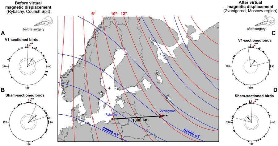
Figure 1. Magnetic map navigation in a migratory songbird requires trigeminal input
Centre: map of natural magnetic field parameters of the capture site (Rybachy, Kaliningrad region) and the site of virtual displacement (Zvenigorod, Moscow region). The solid arrow on the
map shows the virtual displacement direction and distance. The red and blue lines on the map are the magnetic declination and magnetic intensity isolines, respectively. The circular
diagrams show the orientation of the Eurasian reed warblers tested at the capture site before surgical treatment and virtual displacement ((A) real V1-sectioned group, (B) sham-sectioned
group) and the same birds’ orientation after a purely magnetic 1,000 km virtual eastward displacement ((C) V1-sectioned group, (D) sham-operated group). Each dot at the circle periphery
indicates the mean orientation of one individual bird; arrows show mean group vectors; the dashed circles indicate the radius of the group mean vector needed for 5% and 1% levels of
significance according to the Rayleigh test of uniformity; solid lines flanking mean group vectors give 95% confidence intervals for the group mean directions. Geographic North
corresponds to 0°, magnetic North (mN) is shown by a red triangle outside the circle (+5.5° declination in Rybachy and +10.1° declination in Zvenigorod). The map was produced in
R 3.2.5 (R Foundation for Statistical Computing, http://www.R-project.org/) using packages “map”, “mapproj” and “mapdata”.
Reference: Pakhomov A., Anashina, A., Heyers, D., Kobylkov, D., Mouritsen, H., and Chernetsov, N. (2018) Scientific Reports 8, 11975 (supported in part through Russian Science Foundation
grant #17-14-01147 led by Dmitry Kishkinev)
DOI: https://doi.org/10.1038/s41598-018-30477-8
Web-link: https://www.nature.com/articles/s41598-018-30477-8.
Copyright: This figure is licensed under a Creative Commons Attribution 4.0 International License, which permits use, sharing, adaptation, distribution and reproduction in any medium or
format, as long as you give appropriate credit to the original author(s) and the source, provide a link to the Creative Commons license, and indicate if changes were made. The images or
other third party material in this article are included in the article’s Creative Commons license http://creativecommons.org/licenses/by/4.0/.
The question how migratory animals, especially migratory birds, are able to reach distant destinations is one of the most discussed questions in current biology. Some bird species are
capable to perform long-distance navigation. Numerous displacement experiments with a growing list of bird species have clearly shown that displaced birds can reach migratory destinations
even from unfamiliar regions situated far aside from their migratory routes. The question what natural cues birds use for positioning and navigation remains unanswered. A conceptual
approach to explain bird navigation was proposed in the mid-20th (Kramer 1953) and assumes a two-step process by solving navigational task: first, the animal determines its position
relative to the goal (a 'map' step), and second, the animal chooses and maintains direction leading towards its desired goal (a 'compass' step). Whereby the natural cues used for these
two steps could be different. In the last 60 years, the nature of compass cues and compass sensory mechanisms have been actively studied. It is now well established that birds can use
stars, solar and geomagnetic cues for directions (Wiltschko & Wiltschko 2015; Chernetsov 2016 for reviews). However, the sensory nature of the 'map' (or positioning) system remains
understudied. This project will address the sensory nature of the 'map' and sensory mechanisms required for navigation in birds. We will build on the literature and our own recent
achievements in the field of bird navigation. Currently, there aretwo most discussed and not mutually exclusive hypotheses explaining sensory nature of bird navigation - a magnetic
navigation hypothesis and an olfactory navigation hypothesis. Some researchers have assumed that different natural cues may fit best for different geographic scales and/or different
ecological groups of birds may have been adapted to perform navigation using appropriate environmental cues. More specifically, studies using some seabirds (e.g., shearwaters and gulls)
and homing pigeons (Columba livia f. domestica) have suggested that the sense of smell is important for their navigational abilities supporting the olfactory hypothesis. It remains
unclear however whether all or only some birds use olfaction for navigation, what volatile compounds (odours) are used for positioning and what is the geographic scale where such an
approach is suitable. In parallel, our recent studies in some songbird species (Eurasian reed warbler, Acrocephalus scirpaceus) have strongly suggested that the geomagnetic field is
necessary and sufficient for positioning across large (100s of kilometres) distances. The latter supports the magnetic navigation hypothesis. We will apply an integrated set of
approaches to study the role of both magnetic and olfactory senses for bird navigation, and experimentally examine the two hypotheses of navigation across different geographic scales
spanning from a just a few to > 1,000 kilometres. We will also test the hypothesis that putative magnetoreceptors may co-locolize with olfactory receptors.


